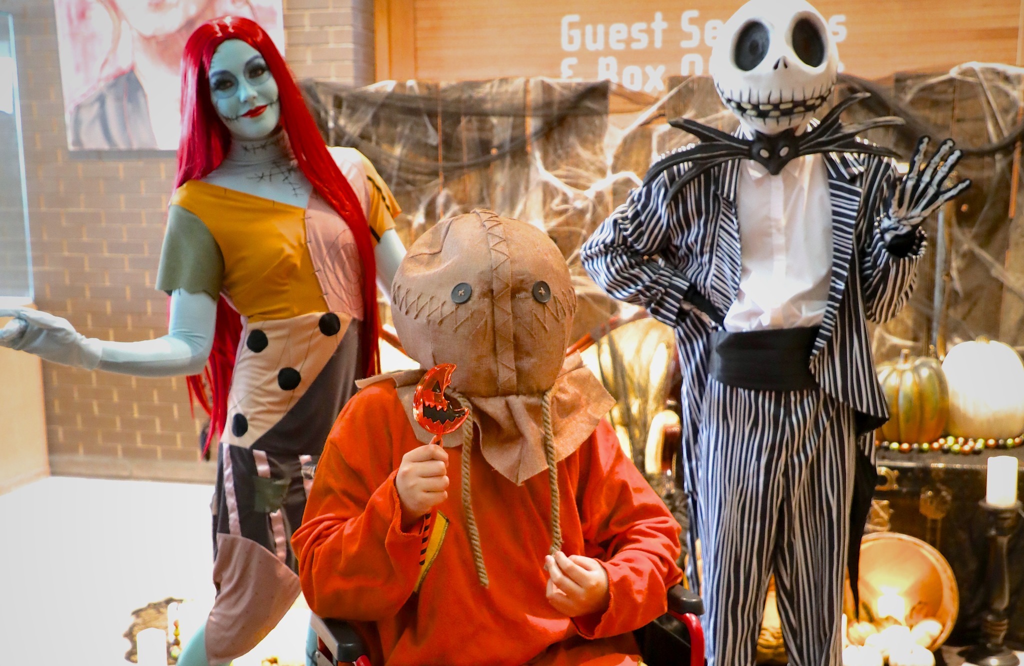
Turn 'er Loose
The 1917 Medicine Hat Exhibition and Stampede
.jpg)
The 1917 Medicine Hat Exhibition and Stampede
The phrase, “Turn ‘er Loose” for those unfamiliar with a rodeo is a colloquial expression often used by a cowboy or bronc rider immediately before the bucking chute is opened or in earlier times when the horse, having being held down by other cowboys, is mounted by the cowboy and is given as a signal to “let” the horse go, in order for it to be ridden.
In early 1916, the Department of National Defense discontinued the military training of “mounted” rifle regiments, as horses no longer served a useful purpose on the battlefield. The Exhibition Grounds in Medicine Hat, which previously had been used for this type of training, was abandoned, leaving behind a number of buildings including horse barns and horse stalls, which had the capacity of accommodating over 500 horses.
With the facility being available, the idea of re-establishing the annual Exhibition in 1917 was discussed openly and it became the “talk” of the town with many prominent businessmen and ranchers promoting the idea. One of the most unlikely proponents and one of the first to mention the holding of a “Stampede” in connection with the Agricultural Fair was the parish priest at St Patrick’s Church, Father O’Mara. In an uncharacteristic letter to the editor of the Medicine Hat News, he argued in an emphatic and quite convincing fashion, for the need for a Stampede in order to bring people together and to celebrate. He penned the following:
If we are going to aim at having as successful show as possible next year, why not buck up and have a Stampede as one of the features and drawing cards for the 1917 show. Why should Medicine Hat not have the very best Stampede in the West. Bear in mind that Medicine Hat invented the “Stampede” as far as the West is concerned. Pity while we were smart enough to invent the Stampede we were too slow in taking out a patent for the invention.
The passionate letter appeared to attract attention and another clergyman, The Reverend John Morrow, Minister of St. John’s Presbyterian Church, took up the cause and at a public meeting held to discuss the matter emphasized in an address to the gathering, the need or importance of having a Stampede in conjunction with the Agricultural Fair. His plea struck a responsive chord. From that time on, any reference to a competition involving cowboys and their horses in Medicine Hat was known as a “Stampede” and the use of the generic term “rodeo” fell into disfavour.
A Special Meeting was held in January 1917 with a large and enthusiastic group of citizens and a Stampede Committee was formed with the stated objective of “having the greatest Stampede in Western Canada”.
After months of work by one of the largest volunteer groups ever assembled in Medicine Hat, Stampede week started on July 9th, 1917.
A Stampede parade and Stampede Queen contest and open-air street dances and more formal galas became part of the festivities.
“Turn ‘er Loose” became the marketing theme for the Stampede showing up on posters, banners and bumper stickers and by any standard, the first Medicine Hat Exhibition and Stampede was a tremendous success and by some accounts had put a similar event in Calgary “to shame”.
With Medicine Hat only having a population of 10,000, over 29,000 people paid to attend the four Stampede performances and its obvious success financially and otherwise proved to be the cornerstone for the current Medicine Hat Exhibition and Stampede, which continues on in similar fashion today but on a much grander scale.

From amateur to professional leagues, attend a thrilling game in Medicine Hat.
Tigers games at the Co-op Place are a true community experience from the “Go Tigers Go” chants, to lining up among friends at the concession stand. The Medicine Hat Tigers is a junior hockey team in the Western Hockey League that was established in 1970.
A summer game is a staple event for baseball fans in the city. Families and friends of all ages lather on sunscreen and dress in their best ‘Mavs’ wear to sit in the sunshine and watch an exciting and competitive game.
Medicine Hat College Rattlers boasts local, provincial, national, and international talent from its athletes and coaches. The Rattlers compete in basketball, volleyball, soccer, golf, cross country, ice hockey, and futsal. You can cheer them on at a home game just about every weekend from September through February.
Feel the exhilarating thrill while cars race to the finish line underneath the summer sun. With a drink in hand, and popcorn or a hot dog in the other, watch racers from Alberta, Saskatchewan, and British Columbia drive the only paved track in central and southern Alberta. Medicine Hat Speedway is celebrating its 40th anniversary in 2024.
From street cars to motorbikes, driven by junior dragsters and professional racers, the Medicine Hat Drag Racing Association hosts over a dozen high-intensity, family-friendly events every year.

July 23-26, 2025
For over 130 years, the Medicine Hat Exhibition & Stampede has been a community gathering place. The family-friendly, four-day event that originated in 1887. It’s a celebration of western culture and heritage with exciting rodeos, a pop-up amusement park, and a range of ticket-entry and free entertainment. Medicine Hat Exhibition & Stampede continues to bring urban and rural communities together near the end of July, for thousands of people to enjoy their summer days and be entertained for as long as their hearts desire.
Methanex Kiddies Day
A day for the kids is planned, where they can enjoy hotdogs, popsicles, face painting, and bouncy castles. Games for different age groups are planned, like watermelon eating contests and scavenger hunts. This day is dedicated to bringing all the fun to your children during the Stampede.
Night Shows
The night shows are held at the Grandstand on the Stampede Grounds. Well-known bands perform their most popular and loved tunes, while community members and visitors live in the moment and dance to the live music underneath the stars. Continue making more memories to look back on into the evening after you’ve spent the day out in the sunshine.
The Rodeo
This is the heart of the Stampede. You’ll watch athletes participate in chuck wagons, bareback riding, steer wrestling, tie-down roping, saddle bronc riding, team roping, barrel racing, bull riding, steer roping, and more. This action packed rodeo will have your eyes wide open waiting for the next move.
More Rodeo!
There are several venue spaces on the Medicine Hat Exhibition & Stampede land, one of which hosts rodeos from April to July. The Broncs & Honky Tonks Rodeo features Canadian Professional Rodeo and Professional Rodeo Cowboy Association contestants. It’s a popular event where people enjoy watching all rodeo-related activities. Be sure to check the Stampede’s events calendar for upcoming rodeo events.
July 23, 2025 presents Dog Walker with special guests Rent to Own
July 24, 2025 presents Tim & the Glory Boys
July 26, 2025 presents Crash Test Dummies with opener Wide Mouth Mason

Explore Medicine Hat’s Indigenous history with this self-guided tour, made by The Miywasin Friendship Centre and partners.
Police Point Park offered sheltered camping with an abundance of firewood available for First Nations, and it was a safe crossing place for the South Saskatchewan River. The chokecherry bushes and buffalo berries were harvested by First Nations for many years. During winter, an ice-free section of the river was referred to as a breathing hole for the water spirits, and the distinctive cottonwood trees had ceremonial uses. Anecdotal sources said Police Point Park was also used historically as a location for tree burials.
The Old Man Buffalo Stone, made by stone sculpture artist Stewart Steinhauer, was inspired by the Manitou Stone. This two-sided sculpture was crafted to be a guardian watching over the buffalo herds.
Explore the area: Police Point Park has an abundance of paved trails that bring beautiful views of the cliffs and South Saskatchewan River. Visit the Nature Centre to learn more about Indigenous history, the ecosystem, and wildlife in the park.
Located in the valley of Seven Persons Creek, this area was once used as a late winter, early spring buffalo meat processing site by early First Nations. The site dates back thousands of years, and archaeologists believe there are over 83 million artifacts buried in the valley. Visitors are reminded that no digging for artifacts is permitted at the Provincial Historic Site.
Explore the area: Follow the paved trail to stroll the natural area, and then head towards the Saamis Tepee — the World’s Tallest Tepee — to see the site from a bird’s eye view.
This space was a Métis community until the mid-2000s. It was designated a Historic Designation in 2020, and a plaque was unveiled in 2021 that shares more information about the space and photos.
Explore the area: Follow the paved trail to the plaque and where the Métis community was once located. Continue on to see cliff-side views. You can also paddle Seven Persons Creek that runs through the park. Find page xx for more details.
Located along the South Saskatchewan River, Strathcona Island Park was home to First Nations and Métis. The remains of some Métis homesteads are on the south side of the spray park and camp kitchen, although obscured now by time and foliage.
Explore the area: Strathcona Island Park also features a waterpark, playground, boat launch, paved trails, and picnic areas.
Thousands of Indigenous peoples have served in the Canadian Military, including all of the conflicts presented on Medicine Hat’s Cenotaph.
In some cases many members of the same family went overseas to serve, sacrificing much. Four Bliss brothers; Pat, Joe, Bill, and Tassie, served in the trenches of the First World War. Tassie was injured, having his forearm amputated, and Bill struggled in his return to civilian life. Bill enlisted in 1915 at the age of 19 with the third CMR. Bill was wounded at Ypres in 1916 by shell in the trenches. He contracted influenza in 1917 and was discharged in 1919 at the age of 23.
Explore the area: This park is located in Medicine Hat’s Historic Downtown. Nearby is the Miywasin Friendship Centre, where gatherings are often hosted to the public like drum circles and bannock & tea.

Medicine Hat inherited its name from the Blackfoot word “Saamis” which is loosely translated as “medicine man’s hat.”
Several legends tell this story, one of which is beautifully depicted in a sculptured brick mural at City Hall. The legend tells of a winter with great famine and hardship for the Blackfoot nation. The elders of the Council chose a young man to save his tribe from starvation.
After many arduous days he made his way to the “breathing hole”, an opening in the ice of the South Saskatchewan River believed to be the place of the Great Spirit. The young hunter made camp and summoned the spirits who appeared in the form of a serpent.
The Great Spirit told the man to spend the night on the small island (Strathcona Island Park) and “in the morning when the sun lights the cut-banks, go to the base of the great cliffs and there you will find a bag containing medicines and a Saamis (holy bohnet)”. The hat, he was told, was to be worn only in war, and would ensure victory to the wearer.
Aided by the magic of his Saamis, the young hunter located the much-needed game, saved his people, and eventually became a great Medicine Man.
Thus, the first “medicine hat”; a symbol of leadership, prowess, and mysticism on the western plains, came into existence. The city which was destined to perpetuate with its name was founded at the location of the ancient legend.
In 1883, the Canadian Pacific Railway stopped to build a train bridge across the South Saskatchewan River. With the construction, a tent town was born taking the name from the numerous legends. A nearby hill was marked by the name Medicine Hat on a map of the Department of Interior the same year. In the CPR’s search for water, their drills accidentally struck natural gas west of town, heralding the exploration that mapped out one of the largest gas fields in North America, providing Medicine Hat with its moniker “The Gas City”.

Canoe, kayak, boat, or float the waterways in Medicine Hat.
Blue skies, a shining sun, and the feeling of the fresh river breeze while floating the South Saskatchewan River is how a day that ends in ‘y’ can be spent. Echo Dale Regional Park, surrounded by huge coulees, is a captivating start to this experiential river float.
Once you slide your boat onto the riverbend and spring to land on the top, a glance to the right can bring a handful of dogs running, walking, and sniffing the green shrubbery. As they enjoy their daily escapade, you’ll begin yours.
Minutes will melt away as you tan underneath the warm sun and visit with those who’ve joined this adventure. Cold water has never felt so refreshing and fresh air so soothing. Laughter fills the space as you notice friendly wildlife flying above and wandering the river banks throughout the day.
The shimmer of City Hall, and the glow of historic brick buildings pull you towards the downtown core. You’ll float underneath Medicine Hat’s Finlay Bridge, built in 1908, and the Railway Bridge, built in 1883.
As you near the end, and after you’ve taken all the photos your camera roll can handle, Strathcona Island Park welcomes you with fire pits and picnic tables to roast your hotdogs, hamburgers, buns, and marshmallows to end your day with good food, good people, and good memories to look back on.
Desert Blume (Heron Crt. SE) to Kin Coulee Park — best for beginners.
For a wild and adventurous day on the waterway, Seven Persons Creek is the place to be. Throughout an approximate three hour paddle, you may cross paths with deer, beavers, moose, blue herons, ducklings, and geese, while surrounded by large coulees and refreshing natural sights. Completely immersed in the quiet space, with only the neighbouring sounds of nature, this in-city creek isn’t far to find. Paddle the rapids and go with the flow on the winding streamline.
Desert Blume to South Saskatchewan River — best for experienced paddlers.
Paddle among the reeds, rapids, and culverts on the narrow and quick waterway. Ducks and geese may fly as you arrive at their floating spot, and kingfishers might happily hop ahead of you to lead the way. Deer, muskrats, and beavers are other wild creatures that have been seen while paddling this creek. Tall bluffs will tower over you, followed by a canopy of trees. There are many hop-off points once you reach the South Saskatchewan River, where you can join hundreds of seagulls and a few fishing blue herons living a life we often don’t think about in Police Point Park. If this is the paddle for you, make sure to scout the route beforehand — water level is always changing, and there is a short portage you need to be ready for.
“Paddling Seven Persons Creek is wild, adventurous, and you get such an adrenaline rush. Whereas, the South Saskatchewan River is very relaxing and calm. With both, you travel through the coulees and see so much wildlife. The two waterways are like no other; it’s honestly so stunning.” - Teresa Humphries, co-owner of Outdoor Xcape Rentals.
watch the South Saskatchewan River reel here
Rent equipment from Outdoor Xcape Rentals
Join the free summer event Great Big Paddle

Discover the Medicine Hat mountain biking scene.
"The Medicine Hat region at first impression seems like a flat desert grassland, what could it offer in terms of fun and exciting riding? The reality is that here lies a mountain bike oasis when you look a little closer.

With the South Saskatchewan river cutting a deep valley through the region it created a blank canvas for trails to be developed. Then to the east of the city lies Cypress Hills provincial park only a short 65km drive away. Rising up in a striking fashion the provincial park is home to steep hills and thick forest.
From the steep coulee banks of the river to the forest trails of the park, locals have been busy cultivating a network of trails in this section of the Canadian Badlands region. I have had a chance in the past to get a quick feel for the riding in these two zones. Although on those visits I never got a chance to experience a fun full day in Medicine Hat mountain biking for myself."
Things to do in Southeast Alberta.
Easy access, large sites, and few people are all draws for Bow Island’s Centennial Park (pictured at top of the page). Found just blocks from the Crowsnest Highway, the campground has two playgrounds, two outdoor cooking areas, a free shower house, beach volleyball, and a well-maintained soccer field.
Most summer Sundays, the park becomes the hub of the community as many families take the opportunity to visit the park to relax. Kids play at the playground while the adults either play a game of soccer or sit in the shade and visit. An added attraction is “Market in the Park” which takes place every Wednesday, from the first week of July until the last week of August.
403.545-2522
bowisland.com
The sun sure burns hot during Southern Albertan summers making swimming pools welcome oases for any wary traveller. The Bow Island Swimming Pool is mere blocks from the Crowsnest Highway near BowIsland’s surprising downtown. It is a crystal clear, cool oasis featuring a shallow kiddie pool, hot tub, diving board and climbing wall. The climbing wall on the edge of the pool is a unique addition that will simultaneously exhaust, challenge and occupy everyone as long as your forearms can bear. It’s equally challenging for a 6 or 36 year-old to reach the top so there’s no excuse to give it a pass. You’re not chicken, are you?

Pinto McBean – the world’s largest and most armed pinto bean – Bow Island’s answer to the world’s largest bottle of catsup (in Illinois, for you long-haul road-trippers). Pinto McBean celebrates the town’s role in Southern Alberta’s agriculture industry, which is a leader in beans and lentils. The fact that agriculture even exists here is a feat of human engineering thanks to an impressive canal system that delivers nearly a billion cubic metres of waters to farmers.Indeed, with the effort put forth to grow crops in this dry, sun soaked land, the world’s largest pinto bean is an apt, wonderful mascot and a deserving point of pride. Don’t miss it.
Red Rock Coulee Natural Area is 324 hectares (800 acres) of badlands, hard sandstone capped hoodoos and large, round, red boulders. Formed in prehistoric seas as layers of sand calcite and iron oxide collected around a nucleus formed by shells, leaves, or bones. These concretions grew larger as the circulating waters deposited more layers. The reddish colour comes from iron oxide. At up to 2.5 metres (8 feet) in diameter, they are among the largest in the world. Along with the exposed rocks, you will also find prairie inhabitants such as deer, coyotes, rabbits, rattlesnakes, and nighthawks.
To reach Red Rock Coulee, drive southwest from Medicine Hat on Highway 3. Just before the village of Seven Persons you will turn south on Highway 887—a secondary highway to Manyberries. Continue south on Highway 887 until you reach Red Rock Coulee, which is open year-round.

Located on the Red Coat Trail, is the Etzikom Museum and the Canadian National Historic Windmill Centre. The Centre features outdoor restored examples of windmills encompassing over 200 years of Canadian wind power (particularly water pumpers). Indoors at the Museum are many hands-on displays in time-period settings, featuring early pioneer life, native artifacts, fossils, petroglyphs, homesteader tools and a historic church.
Open from Victoria Day weekend to Labour Day weekend
Mon to Sat 10am to 5pm and
Sunday noon to 6pm
403.666.3737
foremostalberta.com
Water in Southern Alberta is a scarce resource, and is depended upon for agricultural livelihood of many. The Saint Mary River Irrigation District diverts nearly one billion cubic metres of water every year to farmers, ranchers and municipalities who need it. While water sustains the livelihood of Southern Alberta’s hardworking people, the canal system that diverts all that water also provides recreation opportunities for everyone. 40 Mile Park is set along a reservoir and has become one of Southern Alberta’s most popular boating, fishing, and RVing spots. The sites are big, the boat launch can handle dozens of vehicles, and the reservoir is big enough for everyone to get on the water.
-min.jpg)
Cavan Lake is a quiet campground and recreation area a short drive from Medicine Hat. Ideal for the fisherman or anyone looking to setup camp and relax, you can choose from large sites in well-treed loop surrounding a playground and open park. Or alternatively, take a site with a view of the small prairie lake and watch the sun rise with coffee in hand. Cavan Lake provides firewood, non-potable tap water,30 amp service and a boat launch for those looking to catch their dinner. Cavan Lake is a short twenty minute drive from both MedicineHat and the Cypress Hills. For those looking for peace and quiet at what feels like their own private fishing hole, Cavan Lake is ideal.
Sandy Point is the first and only rebuttal needed when the idea of the dull, flat prairie comes up. Yes, Sandy Point is proof that breathtaking landscapes can emerge under your feet. The South Saskatchewan river valley at Sandy Point is the Canadian Badlands at its finest. You approach it after 100 kilometres of rolling Alberta prairie, which is hypnotic and remarkable in its own right. Suddenly ranchers’ fields and virgin prairie drop away as you descend into the valley. Hoodoos stretch East andWest along the river and a bright green trestle bridge comes into view.Along the riverbank is a sleepy little campground, a great place to spend the night. Some even use it as a base or finishing point for canoe trips or fishing, with dozens more miles of badlands hoodoos for your eyes only.
-min.jpg)
There are ribbons of blacktop flowing across millions of kilometres of terrain around the world. Novels, poems and love songs have been written about life on the road. The road symbolizes freedom, and adventure. If those novels were written in Southern Alberta, Eagle Butte Road would have been the chapter about solitude and reflection. Cyclists tackle this road to reach Little Plume Church, a small Evangelical church atop a bluff overlooking the surrounding prairie and backed by the CypressHills. It’s a slow grind to reach Little Plume, but the reward is a near constant downhill returning home, to Medicine Hat. Eagle Butte. LittlePlume. Medicine Hat. If those don’t sound like names from Zane Grey’s pen, then nothing does. But they’re real, and they’re here for you.
Starting the descent and hitting the drop offs, laying down some crazy lines on the “Last Grizzly”, getting to grips with some cross country adventure through montane forest high above the prairies…this is Mountain Biking in the Cypress Hills. Over 50km of trails with 240 meters of elevation gain from Elkwater you can bet there will be some challenging moments to get the rewards of the downhill trails. If this is not your thing then take an easier trail and explore some of the viewpoints like Horseshoe Canyon which looks out over the vast prairies or down to Montana Sweetgrass hills from “Head of the Mountain”. An early start and late close to the biking season means you can get on the trails typically from May to October.

Wake up to the morning sunshine and bird song in secluded settings.Feel like you are the only ones around for miles. Get a taste of adventure in the comfort of a cabin. There are over half a dozenCypress Hills Backcountry and Front Country Cabins situated around the Provincial Park. Some you can drive to, some you have to walk to, some have the most basic of amenities and some are pretty much fully equipped. No need to bring your RV or a tent just your sleeping bags, food, water and a little adventurous spirit. Then explore your surroundings in one of the most unique natural settings in Alberta.
The night sky tells an ancient story and in a few places you can see the details of that story more clearly than others. Cypress Hills ProvincialPark is a Dark Sky Preserve where this story can be seen loud and clear.Watch as the day fades and the darkness comes alive with the light of night. Look in the Galaxy and search for shooting stars or see if you can recognize constellations or the planets in our own solar system.Maybe you will be treated to the dancing of the Northern Lights…the night sky comes alive in the Cypress Hills. October to May gives the best viewing although for the night owls the summer can still be a treat.

Redcliff once rivalled Medicine Hat as Western Canada’s manufacturing hub, however between 1913-1915 fires, a cyclone and various other problems, caused many industries to close down. Dominion Glass was one of the surviving operations until it closed its doors in 1989. The factory still dominates Redcliff’s skyline and sits a mere two blocks away from the Redcliff Campground. The campground is nestled in green space between the towns famous Greenhouses where you can buy fresh produce, and the recreation hub of the town including the Baseball Diamonds, Tennis Courts, and Aquatic Centre. Situated only two blocks from downtown, few places can compete with the Redcliff Campground for convenience and price.
Redcliff Riverview Golf Club tracks the South Saskatchewan River and delivers on the promise made by its name. The river views are indeed some of the badlands’ best. Perched on cliffs overlooking the river, even experienced golfers may need another practice swing before sending theirCalloway over a rugged, hoodoo-filled coulee. Although stunning, the view doesn’t necessarily make things easier as the river below your feet can draw the eye towards the horizon. And depending on the time of year, you may be staring down storm clouds looming over a hundred kilometres away. Yes, Canada’s badlands landscape can certainly play tricks on you. Keep your cool, admire the view, take a breath, and swing for the fairway.
Interwoven into the hoodoos and rugged, dusty cliffs of the SouthSaskatchewan River are the Redcliff mountain bike trails. In fact, it is these cliffs – many red from oxidization – from which the town of Redcliff gets its name. The trails here may be Southern Alberta’s answer to Moab.They are built and maintained by a group of volunteers and national trail building experts and are free for all to ride. There are multiple access points in Redcliff to the Green, Blue & Black runs. This is badlands mountain biking terrain at its finest. For trail head details see www.trailforks.com.

Riding the gentle edge of the South Saskatchewan River’s northern slope, Burnside is a short green run that connects to Redcliff’s rugged terrain and series of blue and black runs. Don’t get complacent though, you’re still in the Canadian badlands! Cactus can be found off the well maintained trail and foreshadowing of what’s to come in the way of rock features are fun ways to warm up and are easily to by-pass should the rest of your party not be as keen. It’s a wide, flowy trail that runs in both directions so even if Redcliff isn’t the ultimate destination, there’s plenty of room for a quick there-and-back. Round-trip is about 11 kilometres, making it an easy way to get a quick run in.
Echo Dale Regional Park is one of Medicine Hat’s most popular family destinations. Situated in the South Saskatchewan River valley with badlands views, two reservoirs provide swimming or water sport activities, including stand-up paddle board, kayak or paddleboat rentals.The swimming is served by a cafeteria offering ice cream, snacks and even burgers and fries. Echo Dale Farm is a well-preserved early pioneer settlement complete with a wooden house, barn, blacksmith shop, and former entry to an early-era coal mine. Together, the grounds provide a glimpse into early pioneer life on the prairies. Easily accessible by foot or bike from Gas City Campground or by car via the well-travelled Holsom Road, Echo Dale Regional Park is a family favourite.
Perched high above the South Saskatchewan River, just minutes by foot from one of the best views of Medicine Hat’s river valley is Gas City Campground. It is also the starting point for a path that tracks the bench above the South SaskatchewanRiver to Echo Dale Regional Park, an easy walk for any family looking to spend a day together. The unique campground name comes from Medicine Hat’s long tradition of referring to itself as the Gas City, owing to early twentieth century discovery of natural gas that literally fuelled the city’s early economic boom.English author Rudyard Kipling famously wrote that Medicine Hat had ‘all hell for a basement,’ when discussing the city’s enormous potential. The fully treed,97-site, full-service campground is only minutes from the Trans-Canada Highway.

35 kilometers / 22 miles
A must-see attraction for anyone interested in rural history, this museum portrays various aspects of pioneer life. They have many artifacts and buildings including an old schoolhouse, church, and lumber store. Be sure to check out Irvine’s 20 Milepost Days held annually on September long weekend. This event features all kinds of events, including a parade, rodeo, gymkhana, bench show, and much more.
403.834.3923
158 kilometers / 98 miles
Discover and experience a unique landscape of haunting formations and rich fossil resources at Dinosaur Provincial Park. You will be amazed when the gently rolling prairie grasslands suddenly drop off, plunging the visitor into a remarkable world of hoodoos, pinnacles, coulees, and buttes.
A UNESCO World Heritage Site situated along the Red Deer River just 90 minutes west of Medicine Hat, the Park is the largest area of badlands in Canada and one of the richest sites in the world for late Cretaceous fossils.
Take the Trans-Canada Highway west to Brooks, then go north on Highway 873, east on Highway 544 to PR 130 at Patricia. Follow the big blue Provincial Park signs along the way.
To book tours and learn more
403.378.4344
dinosaurpark.ca
For campground reservations:
Reserve.AlbertaParks.ca
1.877.537.2757