Southeast Alberta
Autumn Road Trips from Medicine Hat
Nothing beats a beautiful Autumn Sunday on the road!

Nothing beats a beautiful Autumn Sunday on the road!
Finally, it’s Autumn! The season where us fair weather folks thrive. Comfortable temperatures, beautiful fall colours, apple cider, pumpkin pie, spooky decorations — it really is a season worth waiting for. Summer gets all the glory of being the perfect time for family road trips, but nothing beats a beautiful Autumn weekend on the road, where life feels a little slower and there are so many fun activities to enjoy. Here’s a great list of can’t-miss locations for you to check out.
Enjoy the Fall Colours in the Cypress Hills
If you have never seen the Cypress Hills in the fall — NOW IS YOUR CHANCE! The Cypress Hills are absolutely beautiful this time of year, lit up with vibrant orange and red foliage. Perfect for a warm day’s hike or even just to drive through, it’s worth the stop.
Open: Any time!
Directions: To Elkwater, head East on the #1 towards Swift Current, turn right onto the 41, Buffalo Trail, and follow the signs.
Explore the Corn Maze in Brooks
Located just an hour away, the Brooks Corn Maze is the closest attraction of its kind for Medicine Hatters. Once you are done finding your way through the maze, the farm has many other activities like picking your very own pumpkin in the pumpkin patch, magnetic fish pond, mini golf, train rides, and farm animals to pet.
Open: Saturdays and Sundays from mid-August to the end of October, 1-5 pm.
Directions: South of the City of Brooks. Take 7th Street East South, cross the CPR train track, turn left (East) on Industrial Road, in a 300 meters drive through the gate.
Grotto Gardens Family Fun Farm
A petting zoo, mini golf, and farm train tours that are wheel chair accessible, this farm has it all. On the train, visitors will have a guided tour that winds around the animal pastures through the berry orchard, around the perennial gardens, flower displays, and past the other farm animals who make their home at Grotto Gardens. There is oppurtunity for families to feed the farm animals.
Open: Tuesday to Sunday from 11a.m. - 7 p.m.
Directions: 21 Saskatchewan 1, in Maple Creek, Saskatchewan, about an hour heading east on the Trans-Canada Highway.
Pick Your Pumpkins and Go For a Wagon Ride at Molnar’s Pumpkin Festival
Heading West on the #3 highway, Molnar’s Pumpkin Festival is just past Taber and a perfect spot for some pumpkin picking festivities! Along with spying that perfect pumpkin to carve up, Molnar’s has a mini corn maze, pony rides, bouncy house, and wagon rides.
Open: Saturdays and Sundays for the month of October, 10am-2:30pm.
Directions: Barnwell Range Road 173, Barnwell, AL T0K 0B0.
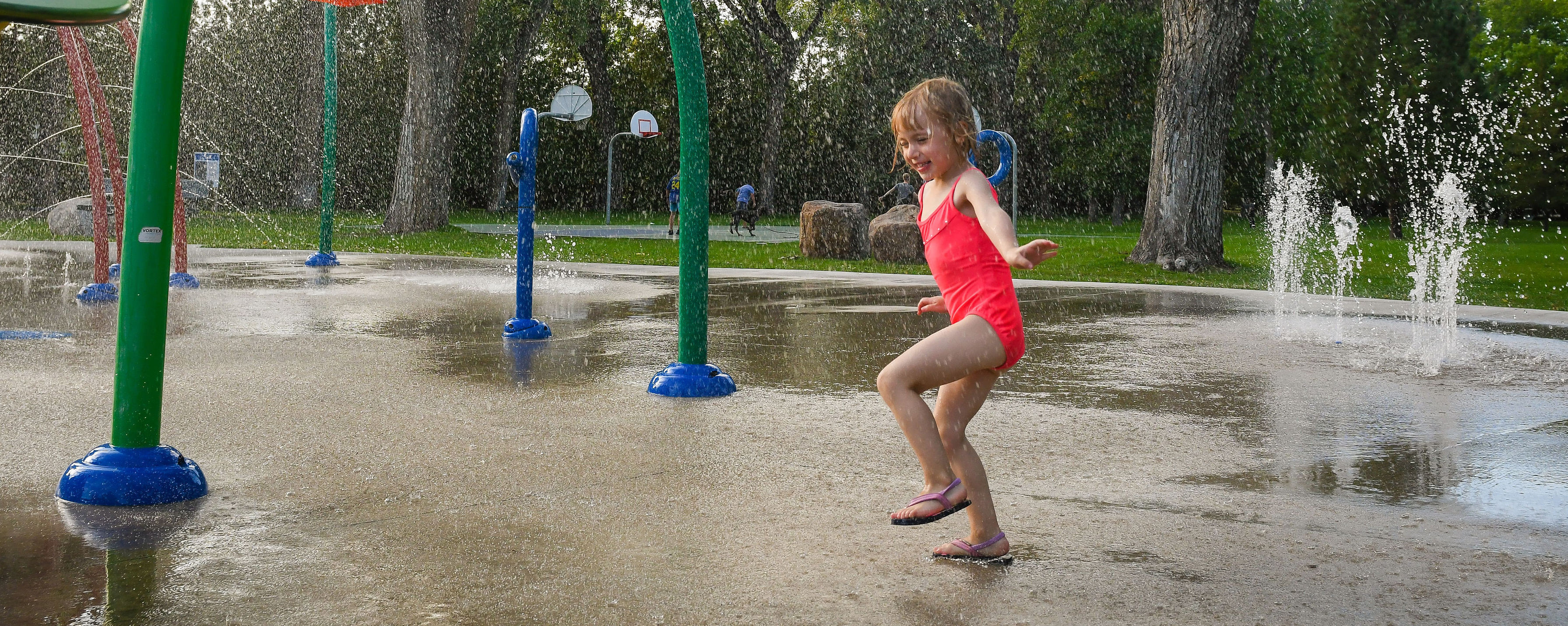
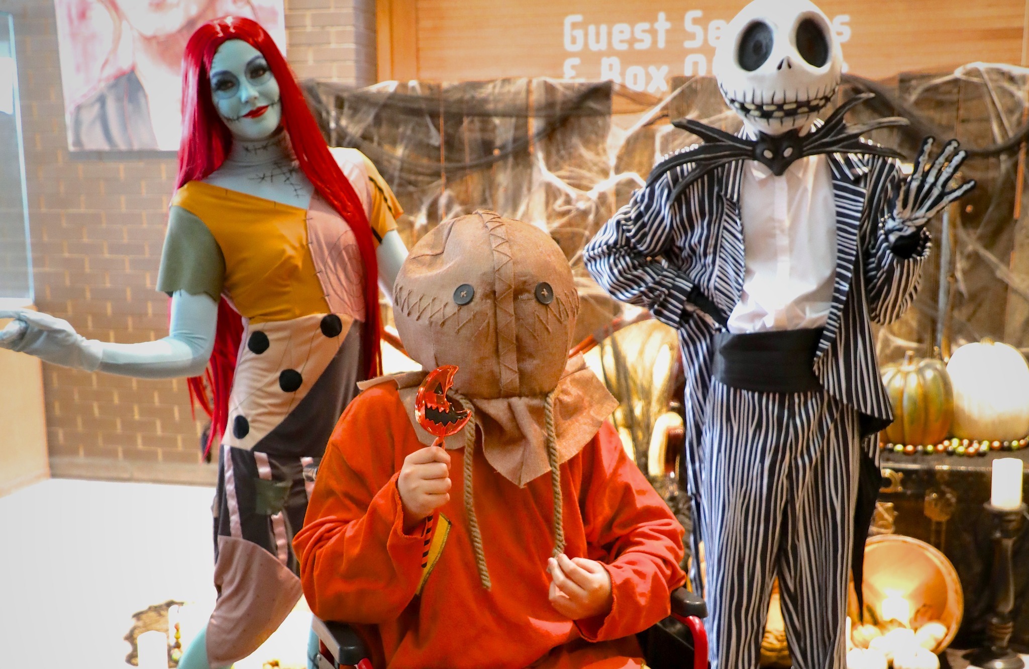
School has started up, but that doesn’t mean the outdoor fun has to end!
School has started up, but that doesn’t mean the outdoor fun has to end! Get that last dose of summer heat and sunshine in with this handy list of outdoor activities and their planned closure dates in the coming weeks:


Bring your family on an adventure to three Southeast Alberta destinations!
Medicine Hat is close to so many nearby attractions that make for a great day trip. Whether you’re by yourself, a group of friends, or for the whole family, these locations are sure to be boredom busters!
Head Towards the Hills
A popular day trip for locals and visitors alike is to Elkwater, in Cypress Hills Interprovincial Park. Don’t miss the treasures along the way, like the Prairie Memories Museum in Irvine.
A must-see attraction for anyone interested in rural history, this museum portrays various aspects of pioneer life. They have many artifacts and buildings including an old schoolhouse, church and lumber store. Be sure to check out Irvine’s 20 Milepost Days held annually during September’s long weekend. This event features all kinds of events, including a parade, rodeo, gymkhana, bench show and much more.
In Elkwater, there are many options for activities such as renting paddle boards, hiking the trails, riding horses, relaxing on the beach or mini golf. If your group is looking for a bite to eat, is always a great stop.
Stick around after the sun goes down, the Cypress Hills are a Dark Sky Preserve. Due to its high elevation and lack of urban light pollution, Cypress Hills was the first designated Dark Sky Preserve in Alberta. The park also offers a variety of camping options, so cozy up by the campfire and gaze at the starlit sky. If the conditions are right, you may even see the Northern Lights.
Explore the Badlands
Head west on Highway 3 to find some of the most breathtaking natural views in the area. Start off your adventure at Red Rock Coulee.
Red Rock Coulee Natural Area is 324 hectares (800 acres) of badlands, hard sandstone capped hoodoos and large, round, red boulders. Formed in prehistoric seas as layers of sand calcite and iron oxide collected around a nucleus formed by shells, leaves, or bones. These concretions grew larger as the circulating waters deposited more layers. The reddish colour comes from iron oxide. At 2.5 metres (8 feet) in diameter, they are among the largest in the world. Along with the exposed rocks, you will also find prairie inhabitants such as deer, coyotes, rabbits, rattlesnakes and nighthawks.
Once you have had a chance to explore your first stop, continue on towards Etzikom for the Etzikom Museum and Historic Windmill Centre.
The Centre features outdoor restored examples of windmills encompassing over 200 years of Canadian wind power (particularly water pumpers). Indoors at the Museum are many hands-on displays in time-period settings, featuring early pioneer life, native artifacts, fossils, petroglyphs, homesteader tools and a historic church.
Next up, hop over to Writing-on-Stone Provincial Park to view some of the coolest hoodoos and natural formations in Southern Alberta. The unusual landforms of Writing-on-Stone / Áísínai'pi resulted from the dynamic interaction of geology, climate, and time. The sedimentary rocks exposed in the Milk River valley were formed 85 million years ago at the edge of a great inland sea. Huge volumes of meltwater began eroding the soft sandstone after the last ice age. This is how the coulees and hoodoos you see today were formed. The unique habitat created is suitable to many diverse species not typically found in surrounding areas.
On the way home, head north and go through Bow Island, where you can visit Pinto Mcbean, the 15-foot-tall mascot of the bean capital of the West, and grab a bite to eat. We recommend The Rolling Pin Bakery and Cafe, a local favourite serving up some of the best lunch in the region.
Walk with the Dinosaurs
Discover and experience a unique landscape of haunting formations and rich fossil resources at Dinosaur Provincial Park. You will be amazed when the gently rolling prairie grass
lands suddenly drop off, plunging the visitor into a remarkable world of hoodoos, pinnacles, coulees and buttes. A UNESCO World Heritage Site situated along the Red Deer River just
Just 90 minutes west of Medicine Hat, the Park is the largest area of badlands in Canada and one of the richest sites in the world for late Cretaceous fossils.
While you’re in the area, don’t miss Lake Newell, considered one of Alberta’s best kept secrets! Lake Newell, located 14 kilometres south of the City of Brooks in the Newell region, is one of southern Alberta's largest and warmest human-made lakes. The clear warm waters are perfect for canoeing, sailing, fishing, swimming, motorized water sports and more. Visitors can camp at Kinbrook Island Provincial Park, which is situated right on Lake Newell, or stay in one of the many options within the City of Brooks. Extend your stay and enjoy some of the nearby attractions, including the Brooks Aqueduct and the world-famous Dinosaur Provincial Park. Lake Newell is also home to Lake Newell resort, which includes a marina and boat launch facilities.

A road trip isn't complete without your best friend.
But when your BF has four legs, logistics are a little more complex, especially with the summer heat. Almost all patios are pet friendly in Medicine Hat, so we recommend calling the eatery you'd like to dine to make sure. Here are a handful of recommendations below:
Hell's Basement Brewery are true dog lovers, with many of the staff bringing their furry friends with them to work. Hell's Basement has expanded their drink options for all tastes, and their patio is family-friendly. If beer isn't your thing, pick from the rotating list of seltzers, hard sodas or try the non-alcoholic Heck-of-a Root Beer!
This bustling eatery has a great outdoor setup in the heart of downtown Medicine Hat. With a great menu and even better beverage selection, serving all of our city's brewery and distillery options, you won't be disappointed. Dogs are welcome on the boardwalk of the patio, which is set up only during the summer months.
Find a dish on their full menu and enjoy the 'out-of-town' feeling of this rustic patio, with a selection of 23 timeless craft beers on tap to choose from. This brewery is on the outskirts of town, so if you're just stopping through for a quick bite to eat (and to fill your growlers), you and your furry friend don't have to venture too far off the trail. Especially handy if you're hauling a camper.
With a brand new kitchen and revamped menu, the Silver Buckle is a popular local hangout with a dog-friendly patio and frequently has live music. Check their socials to see their most recent events.
The perfect place to stop for a coffee and enjoy the sunshine on the patio. Located downtown, it's a great stop while doing some shopping, sightseeing or enjoying nearby city parks. There is also delicious food (light meals) and treats (often GF options available).
If you're looking to satisfy your sweet tooth, Swirls is a must-visit. This Medicine Hat staple is the perfect pitstop for you and your pup to grab a cone. Their offerings are never-ending and even include vegan ice cream options.
Medicine Hat's newest brewery and latest patio addition. Sit in the sunshine and sip on a brew or kombucha downtown on 3rd Street. Travois Ale Works routinely features new brew creations, like their immediately famous Purple Haze and newly featured food menu.

Must-see chainsaw carvings around Medicine Hat.
Five years ago, Marina Cole had never used a chainsaw. Fast-forward to 2021, and she is finishing up yet another awe-inspiring wood carving in Medicine Hat.
Cole who lives in Irvine Alberta, only 15 minutes from Medicine Hat, takes old, dead trees and gives them new life by transforming them into works of art. Over the past few years, Cole has created must-see chainsaw carvings throughout the city.
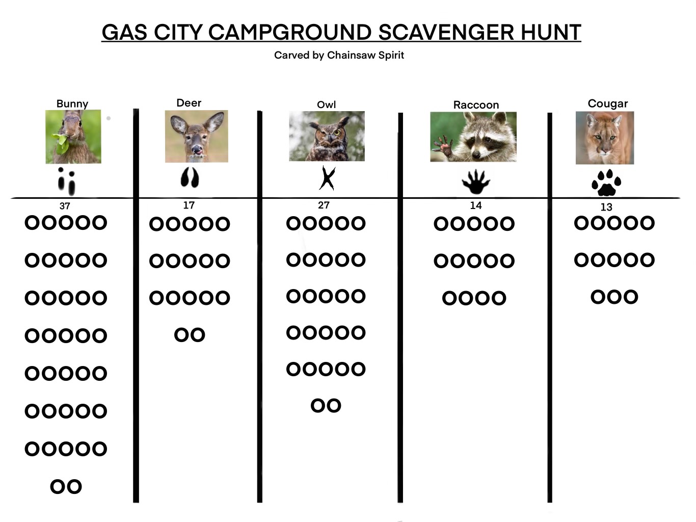
Cole’s sculptures at Gas City Campground were created with the intention of getting young children out and teaching them about the animals they may encounter during their stay.
“There are probably ten or more and there is also a small scavenger hunt for kids to complete based around the tracks of different animals that live in the area. Kids can spend a day running around the park looking for all of them.” says Cole who in addition to being an accomplished sculptor is also a mom.
While it is not the largest or most well-known park in the city, Dan MacCharles Park is home to an amazing Dragon Sculpture by Cole. Cole created the dragon’s body out of a tree stump, then added the wings, which she carved separately. How many other cities can say they have a resident dragon?
“I heard it was a dragon spruce that was coming down, so it just made sense to make a dragon,” she says. “The dragon is one of the cooler pieces I’ve done” says Cole.
Another of Cole’s earlier works, is the tall sculpture celebrating all things Canada and Canadian heritage. Anyone walking the Kin Coulee loop on a summer afternoon will notice the sculpture just past the Kinette Corner near the baseball diamond.
Cole allows the material and her intuition guide her creative process often without a clear vision of the finished sculpture.
“Sometimes you start working, and things come together.” says Cole. “I did the first three pieces and then had a fourth stump to carve . I didn’t know what I wanted to do with it, but as I worked on those first three pieces, I noticed so many people walking their dogs at the park. After I finished the bear, mushroom and the house, I created an ‘Ode to Dog Walkers’ that is dedicated to everyone walking their dogs through the park.”
Many who grow up in Medicine Hat have fond memories of Kiwanis Central Park and the whale slide residing in it.
Cole’s four sculpture pieces at the park now provide a new generation of Medicine Hat children with memories, and offer unique photo opportunities to those passing through the city.
The piece at the Medicine Hat Exhibition & Stampede is a collaboration of what the stampede is all about, including bull riding and horses, and also a memoir for the Indigenous children that were taken from their families.
“When you walk around the back of the carving, you’ll see an eagle with the look of a young boy and girl in the wings,” says Cole.
Cole’s latest work and possibly her most breathtaking so far should be finished by the end of April. An angel sits atop the stump of a tree that collapsed during a 2018 windstorm at a heritage home in the Medicine Hat Flats.
Cole says the piece can have different interpretations. “I think it’s definitely going to change from person to person. To some, this could just be art they find cool,” she said. “For others, the angel can have a bit of a deeper meaning.”
In November 2021, Cole decided to showcase other artists around the province and opened Chainsaw Spirit Gallery in Irvine, Alberta. Here, you can find a number of her pieces for purchase, as well as other artistic, hand-made home decor items.
.jpg)
Andy Kirschenman said it best in his must read blog post featured on Pinkbike;

"Redcliff, Medicine Hat and Cypress Hills have kilometres of trails and spectacular views of our beloved prairies and badlands. The Badlands play host to two distinct riding landscapes within an hour of each other, making it an exciting and unique riding destination. Our climate rewards us with very short shoulder seasons and offers one of Canada's longest riding seasons! Our trails are usually good to ride year-round, making it the perfect year-round biking destination."

Kirchmen is a member of the 670 Collective Mountain Bike Club, a registered non-profit, volunteer-run organization affiliated with the International Mountain Bike Association (IMBA).
Read the full article “But Aren't the Prairies Flat? Getting Down in Southeast Alberta.”

Located in the beautiful Canadian Badlands, they are the voice for the mountain biking community in Medicine Hat and the surrounding area. The 670 Collective, together with its more than 200 members, gives back to its community by designing, building and maintaining sustainable trails in Medicine Hat, Redcliff, and the Cypress Hills Interprovincial Park.
.jpg)
The 1917 Medicine Hat Exhibition and Stampede
The phrase, “Turn ‘er Loose” for those unfamiliar with a rodeo is a colloquial expression often used by a cowboy or bronc rider immediately before the bucking chute is opened or in earlier times when the horse, having being held down by other cowboys, is mounted by the cowboy and is given as a signal to “let” the horse go, in order for it to be ridden.
In early 1916, the Department of National Defense discontinued the military training of “mounted” rifle regiments, as horses no longer served a useful purpose on the battlefield. The Exhibition Grounds in Medicine Hat, which previously had been used for this type of training, was abandoned, leaving behind a number of buildings including horse barns and horse stalls, which had the capacity of accommodating over 500 horses.
With the facility being available, the idea of re-establishing the annual Exhibition in 1917 was discussed openly and it became the “talk” of the town with many prominent businessmen and ranchers promoting the idea. One of the most unlikely proponents and one of the first to mention the holding of a “Stampede” in connection with the Agricultural Fair was the parish priest at St Patrick’s Church, Father O’Mara. In an uncharacteristic letter to the editor of the Medicine Hat News, he argued in an emphatic and quite convincing fashion, for the need for a Stampede in order to bring people together and to celebrate. He penned the following:
If we are going to aim at having as successful show as possible next year, why not buck up and have a Stampede as one of the features and drawing cards for the 1917 show. Why should Medicine Hat not have the very best Stampede in the West. Bear in mind that Medicine Hat invented the “Stampede” as far as the West is concerned. Pity while we were smart enough to invent the Stampede we were too slow in taking out a patent for the invention.
The passionate letter appeared to attract attention and another clergyman, The Reverend John Morrow, Minister of St. John’s Presbyterian Church, took up the cause and at a public meeting held to discuss the matter emphasized in an address to the gathering, the need or importance of having a Stampede in conjunction with the Agricultural Fair. His plea struck a responsive chord. From that time on, any reference to a competition involving cowboys and their horses in Medicine Hat was known as a “Stampede” and the use of the generic term “rodeo” fell into disfavour.
A Special Meeting was held in January 1917 with a large and enthusiastic group of citizens and a Stampede Committee was formed with the stated objective of “having the greatest Stampede in Western Canada”.
After months of work by one of the largest volunteer groups ever assembled in Medicine Hat, Stampede week started on July 9th, 1917.
A Stampede parade and Stampede Queen contest and open-air street dances and more formal galas became part of the festivities.
“Turn ‘er Loose” became the marketing theme for the Stampede showing up on posters, banners and bumper stickers and by any standard, the first Medicine Hat Exhibition and Stampede was a tremendous success and by some accounts had put a similar event in Calgary “to shame”.
With Medicine Hat only having a population of 10,000, over 29,000 people paid to attend the four Stampede performances and its obvious success financially and otherwise proved to be the cornerstone for the current Medicine Hat Exhibition and Stampede, which continues on in similar fashion today but on a much grander scale.

From amateur to professional leagues, attend a thrilling game in Medicine Hat.
Tigers games at the Co-op Place are a true community experience from the “Go Tigers Go” chants, to lining up among friends at the concession stand. The Medicine Hat Tigers is a junior hockey team in the Western Hockey League that was established in 1970.
A summer game is a staple event for baseball fans in the city. Families and friends of all ages lather on sunscreen and dress in their best ‘Mavs’ wear to sit in the sunshine and watch an exciting and competitive game.
Medicine Hat College Rattlers boasts local, provincial, national, and international talent from its athletes and coaches. The Rattlers compete in basketball, volleyball, soccer, golf, cross country, ice hockey, and futsal. You can cheer them on at a home game just about every weekend from September through February.
Feel the exhilarating thrill while cars race to the finish line underneath the summer sun. With a drink in hand, and popcorn or a hot dog in the other, watch racers from Alberta, Saskatchewan, and British Columbia drive the only paved track in central and southern Alberta. Medicine Hat Speedway is celebrating its 40th anniversary in 2024.
From street cars to motorbikes, driven by junior dragsters and professional racers, the Medicine Hat Drag Racing Association hosts over a dozen high-intensity, family-friendly events every year.


.JPG)